
About Kurnool
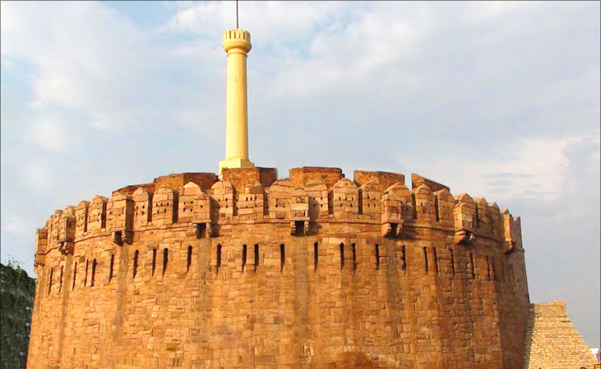
Kurnool is one of the 13 Districts of Andhra Pradesh State. At present Kurnool District comprises 3 Revenue Divisions, 54 Revenue Mandals 53 Mandal Parishads, One Municipal Corporation , 3 Municipalities, 899 Gram Panchayats(Notified – 7, Non notified – 862 ) , 920 Revenue Villages and 615 Hamlet Villages.` It had a population of 3,529,494 of which 23.16% were urban as of 2001.Of historical interest are the ruins of a royal fort dating back to the medieval kingdom of Vijayanagar, which flourished from the 14th to the 16th century. Several Persian and Arabic inscriptions which throw light on various aspects of historical interests are found here. In 12th century AD, the Odder, who carted stones for the construction of the temple at Alampur, Mahaboobnagar District.
On the left bank of the River Tungabhadra, used the site where the town now stands as a stopping place before crossing the Tungabhadra. They greased their cart wheels with oil supplied by local oil merchants and called the place ‘Kandanavolu’ which in course of time came to be known as Kurnool. The City is located about 212 kilometers (132mi) south of state capital, Hyderabad. It is the administrative seat of the district. Kurnool is the gateway to Rayalaseema and largest city in the area. From 1 October 1953 to 31 October 1956, Kurnool was the capital of Andhra State. It has many educational institutions and a major hub for banking and insurance companies. Nallamalas and Erramalas are the two importantmountain ranges in the district running parallelly from Northto South. The Erramalas divide the district into two well defined tracts from East to West. Between Erramalas and Nallamalas lies the Eastern part of the district comprises Nandikotkur, Pagidyala, Kothapalli, Amulapadu, Atmakur, Velgodu, Jupadu Bunglow, Midthur, BandiAtmakur, Gadivemula, Nandyal, Mahanandi, Panyam, Banaganapalli, Avuku, Koilakuntla, Rudravaram and Chagalamarri Mandals. This tract is crossed by the crest of Krishna and PennarwatershedattheNorth part of the Pagidyala mandal at about 1000 above the sea level. Fromthis height the groundslopes to the South along the river Kundu till ittraversesinto Pennarvalley. Major part ofitstractis predominantly black cotton soils. Kurnool District is located in the west-central part of the state on the southern banks of the Tungabhadra and Handri rivers.In Kurnool there are 52 dargahs (shrines) located around the Tungabhadra and Hundri rivers. A very famous and lengthy K.C. Canal starts in Kurnool and ends in Cuddapah. It is around 300 kilometers long. In Kurnool city there are a number of ancient temples, churches and mosques. Kurnool city, known as the gateway to the Rayalaseema, on N.H.7 (Kanyakumari to Varanasi) on the banks of the Rivers Thungabhadra and the Hundri was the capital of the first linguistic state in free India, Andhra State from 1 Oct. 1953 to 31 Oct. 1956. As such it has some historical buildings. It gave birth to the freedom fighters like Vuyyalawada Narsimha Reddy, Gadicharla Harisarvothama Rao. The city posses Zilla Grandhalaya Samstha (ZGS). The District Central Libray (DCL) building which is located near the old Bus stand is named as ‘GADICHARLA HARISARVOTHAMA RAO SMARAKA BHAVANAMU”. It is the second district, apart from Nellore which has contributed two Chief Ministers to Andhra Pradesh namely Bejawada Gopal Reddy ‘Andhra state’ & Nedurumalli Janardhan Reddy. Damodaram Sanjeevaiah (1st Dalit Chief Minister of India and A.P), Kotla Vijaya Bhaskar Reddy 10th Indian Prime Minister P.V. Narasimha rao were elected as MPs from Nandyal constituency with over 6 lakh (6,00,000) majority, and it is a world record. Airport: Rajiv Ghandhi International Airport, shamshabad, Hyderabad( 200 km From Kurnool)